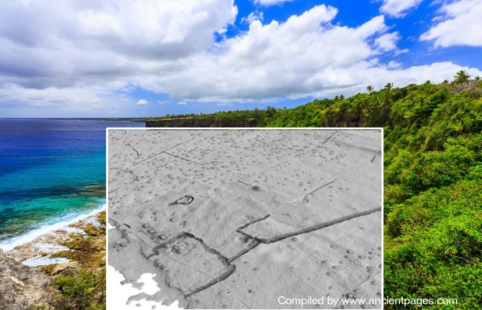
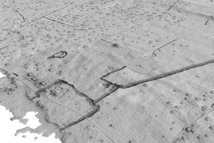
Conny Waters – AncientPages.com – Utilizing advanced laser technology, archaeologists have discovered the remains of an ancient city on the Pacific Island of Tongatapua. Aerial scanning devices, employed for mapping archaeological sites, have identified nearly 10,000 mounds that were once homes approximately 12 kilometers away from the present capital Nuku’alofa in Tongatapu’s eastern district.
According to researchers from The Australian National University, this could be one of the Pacific’s earliest cities. The findings suggest that urbanization occurred in Tonga several centuries earlier than previously believed.
“The Pacific is a region where archaic states and complex chiefdoms developed outside of continental influences and the island of Tongatapu, first occupied by people from 900 B.C. , was the seat of power for a dynastic polity whose influence extended across the south west Pacific. Archaeological evidence and vernacular literature indicate that the Tongan polity flourished from A.D. 1300, and its growth is associated with the construction of monumental architecture, expansive regional trade networks, and complex sociopolitical institutions.
The polity collapsed in the early nineteenth century, in part because of the impact of introduced diseases, although the modern nation-state of Tonga incorporates many elements of the traditional Tongan political systems.
Pacific archaeology has yet to combine the vast settlement information available in lidar datasets with the theoretical advances in our understanding of urbanisation that have emerged elsewhere in the world. Throughout the Pacific, island landscapes—like that of Tonga—are characterised by extensive remains of past built environments, and traditional, terrestrial-based methods of archaeological survey have identified dense concentrations of architectural remains in Micronesia, and Polynesia.
The recent proliferation of lidar based research has produced new records of the built environment that were previously unachievable,” the scientists write in their study.
According to study author and PhD scholar Phillip Parton, the new timeline also indicated that urbanization in the Pacific occurred before Western influence.
“Earth structures were being constructed in Tongatapu around AD 300. This is 700 years earlier than previously thought.
As settlements grew, they had to come up with new ways of supporting that growing population. This kind of set-up – what we call low-density urbanisation – sets in motion huge social and economic change. People are interacting more and doing different kinds of work,” Parton told the ABC Pacific.
In conjunction with a settlement pattern, the collected LIDAR data will provide researchers with valuable insights into the distribution of mounds and fortifications across the Tongatapu landscape. A transportation network interconnects the mound clusters, and recent analyses suggest that between 50,000 and 60,000 people inhabited the island. Starting from A.D. 1300, Tongatapu became home to the Tu‘i Tonga dynasty, whose territorial political institutions extended to other Pacific Islands.
LIDAR discovery of the mounds on Tonga. Credit: Phillip Parton, ANU
These mounds held significant importance in Tongan society. Some served as burial sites, while others had domestic uses, such as forming house foundations. This information is crucial for understanding the island’s historical and societal structures and practices.
Through integrating advanced mapping technology and archaeological fieldwork, the science team has gained significant insights into the historical developments in Tongatapu. This valuable information greatly enriches our comprehension of early Pacific societies. The study of urbanization, a topic that has not been extensively explored until recently, introduces us to a unique perspective on early cities.
A modern view of the mounds. Credit: Phillip Parton, ANU
Contrary to the common image of ancient European cities characterized by dense housing and labyrinthine cobblestone streets, this city has a distinctively different structure.
Parton said the collapse of this kind of low-density urbanization in Tonga was largely due to the arrival of Europeans.
“It didn’t collapse because the system was flawed; it had more to do with the arrival of Europeans and introduced diseases.
The findings also show that Pacific cities were much older than previously thought. This is just the beginning in terms of early Pacific settlements. There’s likely still much to be discovered,” he said.
Illustration of a central place by Gilseman, near Kanokupolu, in A.D. 1643, highlighting the association between meeting places (‘K’), and connections to terrestrial and maritime transport infrastructure. Image from the collections of the Nationaal Archief Nederlanden and is licensed under CC0.
“Locations in the Pacific with dense built remains similar to Tonga, and where the fundamental processes behind settlement growth can also be examined with lidar data, include the built environments of Samoa, and the centre of Nan Madol in Pohnpei. Locations such as Vanuatu and the eastern Torres Strait islands where the built environment remains are predominantly agricultural present contrasting and striking examples of settlement growth trajectories that seemingly did not result in urbanisation.
The mounds are scattered everywhere. Credit: Phillip Parton, ANU
Further advances in our understanding of Pacific societies and their settlement diversity can be generated by additional studies of the type we have outlined here, particularly when combined with Indigenous knowledge, historical observations, and a robust chronological record of a society’s built structures.
We anticipate that these studies are likely to identify diverse settlement systems that will further contribute to our knowledge of urbanisation and the development of complex societies,” the scientists conclude in their study.
The study was published in the Journal of Archaeological Method and Theory
Written by Conny Waters – AncientPages.com Staff Writer

